Разные карты посёлка Пожвы, географическое положение посёлка Пожвы, карты микрорайонов Пожвы: Заратанки, Горы 1, Горы 2, Капустного, Лыскова, Лемпихи.
Создайте Ваш сайт учителя Видеоуроки Олимпиады Вебинары для учителей
Исследовательская работа на английском языке "Карты посёлка Пожвы"
Вы уже знаете о суперспособностях современного учителя?

Тратить минимум сил на подготовку и проведение уроков.

Быстро и объективно проверять знания учащихся.

Сделать изучение нового материала максимально понятным.

Избавить себя от подбора заданий и их проверки после уроков.

Наладить дисциплину на своих уроках.

Получить возможность работать творчески.
Просмотр содержимого документа
«Исследовательская работа на английском языке "Карты посёлка Пожвы"»
“Pozhva’s Municipal Budget School Providing General Education № 1”
The Maps of Pozhva
Made by: Maxim Scochilov,
the studentsof the 10th form
The leader: Lyubov Ivanovna Gorkunova,
the teacher of English
of the highest category
April, 2016
The Contents
The Introduction…………………………………………………………….2
The maps of my Homesettlement ………………………………….............3
a) different maps of Pozhva…………………………………………….3
b) The compatibility of the map………………………………………...3
c) The simplicity of the usage…………………………………………..3
d) The detailing of the map…………………………………………….4
The functioning of the maps…………………………………………4
The detailing of the map……………………………………………..4
The actuality of the map……………………………………………..4
The reliability of the map…………………………………………...4
The geographical position of Pozhva:……………………………………5
the description of Zaratanka;……………………………………….5
the description of Gora I;…………………………………………..5-6
the description of Gora I I;………………………………………...6
the description of Kapustnoe;…………………………………….6-7
the description of Lyskovo;……………………………………….7
f)the description of Lempikha………………………………………..7-8
The Conclusion……………………………………………………………...9
The List of Literature……………………………………………………….10-14
The Supplement……………………………………………………………..15-28
The Physical Map of the location of Pozhva……………………………..15
The Sputnik’s Map of Pozhva……………………………………………..16
The GPS’s Map of Pozhva………………………………………………...16
The Vector’s Map of Pozhva ………………………………………….......17
The Cadastral’s Map of Pozhva………………………………………........17
The Topography’s Map of Pozhva……………………………………........18
The Interactive Map of Pozhva…………………………………………..19
The Map of Pozhva is drawn by Irina Andreevna Gudovshchikova….20
The Map is drawn by the students of the 10th form……………………21
And One of the most suitable Maps to describe the geographical position of Pozhva was done in Kudymkar in 2015……………………………………22
The Map of Zaratanka……………………………………………...23
The Map of Gora I………………………………………………….23
The Map of Kapuctnoe……………………………………………..23
The Map of Gora II…………………………………………………24
The Map of Lyskovo……………………………………………….24
The Map of Lempikha……………………………………………...24
1
The Introduction
My name is Maxim Scochilov. I am 16 years old and I am in the 10th form. I have got a sister. I have a mother and a father. They are workers. I would like to live in the world without wars, crises and drugs, in the world in which everybody is happy, has got the job and is glad to live happily. Now the island of stability and peace for me is my native settlement – Pozhva. And I would like to live in the world which is called Pozhva though my native settlement is really not very big and modern. I love my settlement a small piece of my native land very much.
The topic of the project is “The maps of Pozhva”
The problem of the research work is that there are no good map for describing the geographical position of the settlement at the lessons of English in the 10th form on the topic “How Different the World is!”
The aim of the research work is finding the super map of Pozhva in English for the students of the 10th form” (for describing the geographical position of the settlement)
The tasks of the work are
to form the skills to analyse, systematize, summarize receiving knowledge,
to find the main on the topic “My native settlement, its geographical position”;
to enrich and make more active the linguistic stock of vocabulary, to develop skills and habits of an oral speech on the base of working with the geographical map;
to form skills and habits of working on the map;
to form an emotional, a sensational perception of students of the geographical position of their native settlement.
The sphere of the investigation is English, the map of Pozhva.
The theme of my research work is “The maps of Pozhva”
In this project I decided to know more about the maps of the settlement. I wanted to have a map of Pozhva. I need it to describe the geographical position of Pozhva for studying the topic “How Different the World Is!” in the 10th form.
I am going to describe different places of Pozhva in English. Such as Ratanka, Gora I, Gora I I, Kapustnoe, Lyskovo and Lempikha.
I want you to listen to the information about the settlement’s maps and its places.
I think that it will be interesting to you to know about it in English. 2
2. The maps of my Homesettlement
a) different maps of Pozhva
I found the information about different maps of Pozhva such as The Sputnik’s Map of Pozhva, the GPS’s Map, the Vector’s Map, the Cadastral’s Map, the Topography’s Map, the Interactive Map of Pozhva on the site on which you can find the electronic maps.
Only the register users can to unseal the map in an improving scale.
You have to become an active participant of the association “Routes” to get to the maps of the cities, roads and topographer’s maps.
You can see different photos on this map.
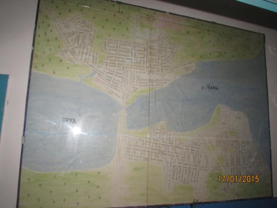
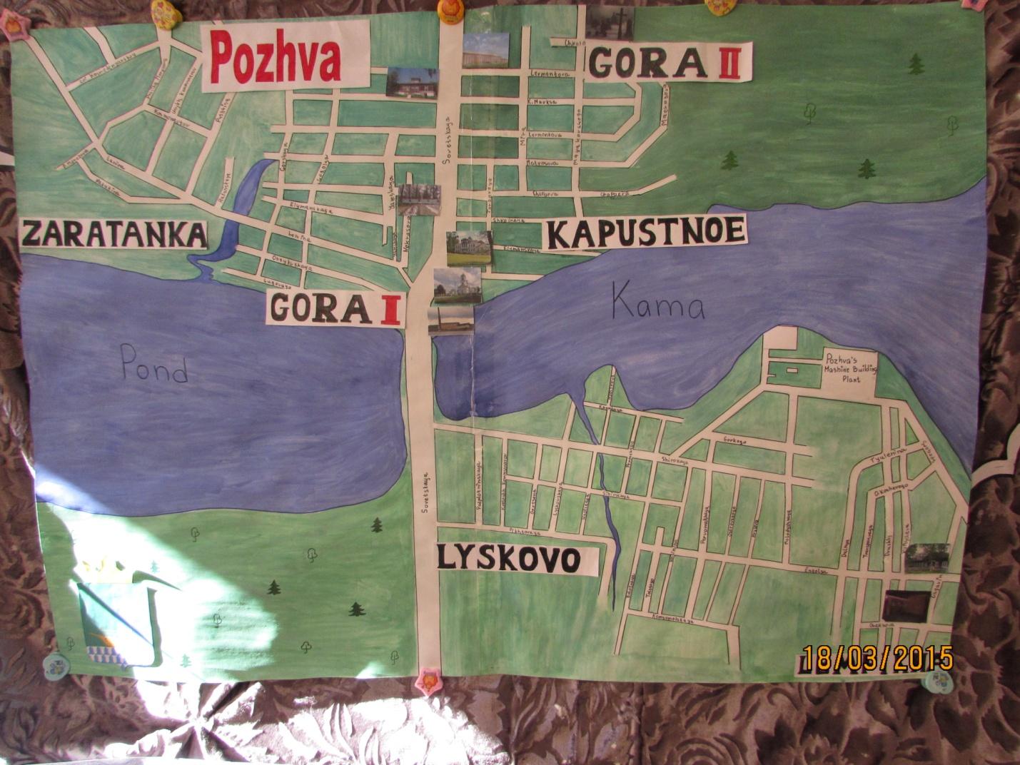
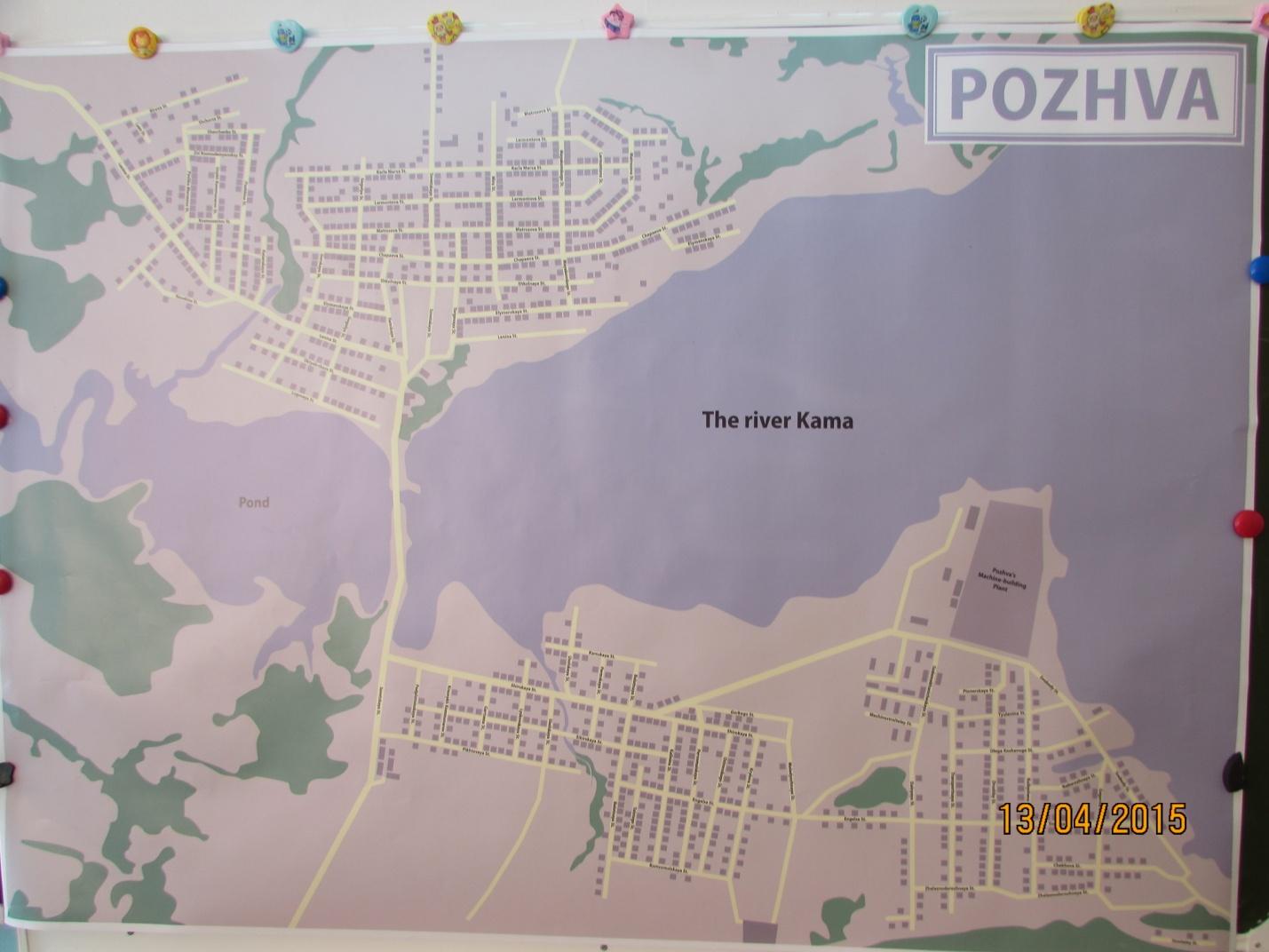
And the Map of Pozhva which is drawn by Irina Andreevna Gudovshchikova. It is in the Pozhva’s Fire brigade. It is large. There are all places of Pozhva there such as: Ratanka, Gora 1, Gora 2, Kapustnoe, Lyskovo and Lempikha. It is the most suitable one to describe the geographical position of Pozhva.
The compatibility of the map
The Electronic map of the settlement Pozhva may be established on the mobile telephones, plane-tables, notebooks, navigators, personal computers and other equipments. Such maps can be established together with all popular navigation programmers such as Garmin, Navitel, Ozi.
If you need a map you may use the unsealing of the map.
The universal compatibility of the maps makes them comfortable for the wide range of users.
c) The simplicity of the usage
The user gets all necessary programmer’s security getting the Interactive Map of Pozhva and the detailed instructions on the setting and the exploitation of the thing.
Besides we carry out the professional and technical supporting on the setting and using the map.
3
d) The functioning of the maps
The drivers will value the maps of the automobile roads of the settlement Pozhva.
There are the main directions, stopping at the yards, the country and the earth roads on the maps.
Besides the suggesting maps have all dignities of the navigation maps, such as routing, the voice conducting, the searching of the objects, the tape-recording of the tracks, 3 D –regime of review and a lot of other things.
The detailing of the map
All the suggesting maps are as much as possible detailed. There are roads, reservoirs, rivers, all the streets with the numbers of the houses.
There are the main sightseeings of Pozhva, the filling stations, the libraries, the canteens, the post-offices, the bus stations, the shops and the road’s signs, the traffic lights, the cameras of the GIBDD.
It is impossible to unseal with such detailing degree of the map of the settlement Pozhva.
The actuality of the map
The settlement Pozhva is one of the dynamic developing regions. That’s why the maps of Pozhva are changing considerably even for a short period of time.
All suggesting maps are renovated in 2015.
Most of them are renovated once in some months.
Thanks to this fact the users get the actual information about the condition of the automobile roads, new constructions and etc.
The reliability of the map
All the maps are checked to be exact and proper in working.
That’s why the users can be sure in their reliability and in correctness of the suggesting information.
4
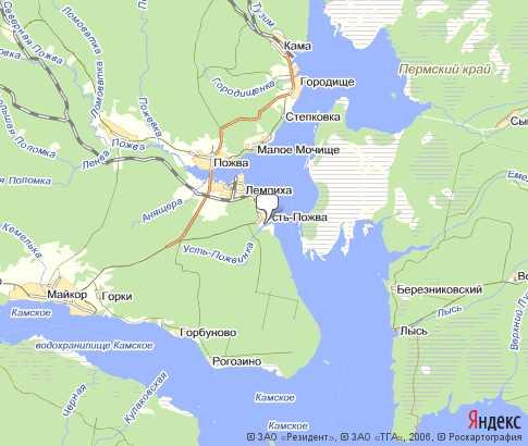
3. The geographical position of Pozhva
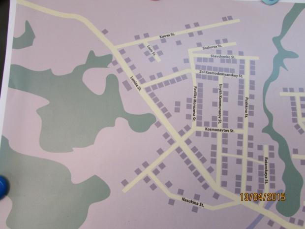
The description of Zaratanka
Zaratanka is another part of Pozhva. It is a medical center of the settlement because our hospital is situated here.
It has got one shop, which is located near the hospital.
Zaratanka is situated on the bank of the river Ratanka in the north-west of the settlement. The river is not lovely for swimming. The fishing is said not to be excellent, either. There is a forest behind Zaratanka. It is a quiet place surrounded by fields and woods. The countryside around this place is green, with fertile fields and rich vegetation, the same as around Lyskovo.
There are 12 streets in Zaratanka. They are: Kirova, Shchorsa, Shevchenko, Lozo, Zoi Kosmodemyanskoy, Pavlika Morozova, Lenina, Kosmonavtov, Nasukina, Unykh Kommunarov, Pushkina and Ratanskaya.
In the south of this place there is a nice pond which is lovely for swimming and boating.
I like this part of our settlement very much. This place is for those people who are looking for peace and a lovely rural environment.
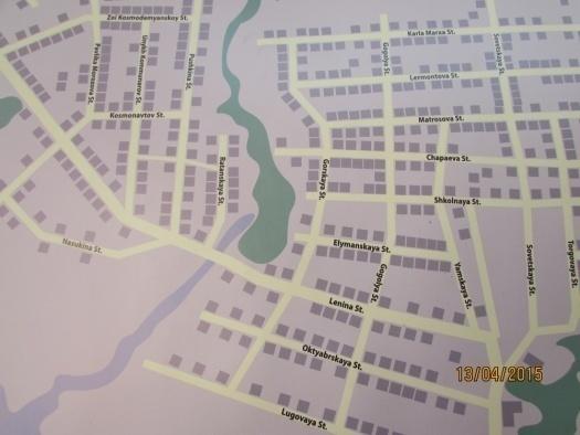
The description of Gora I
Gora I is in the centre of my settlement. It stretches from the river Ratanka up to the Sovetskaya street in the south-west of Pozhva.
There are shops, a library with a museum and a reading-room in it, a kinder-garden “Beryozka”, a Fire Brigade, a post-office, a music school, a garden, a club, a bank.
There is a church a beautiful monument of the past which was built in 1865 by the project of Voronikhin in the style of high classicism.
There are several monuments to the participants of the Civil War and the Great Patriotic War. 5
There are such streets as Lugovaya, Oktyabrskaya, Lenina, Elymanskaya, Gorskaya, Gogolya, Sovetskaya and others.
To the east of Gora I there is Gora II.
There are fields and a forest in the north of Gora I.
I am proud of my settlement. I would like my children to be proud of Pozhva too.
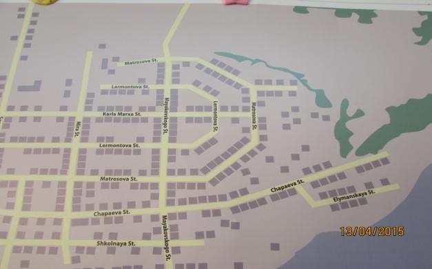
The description of Gora II
Gora II is situated to the east of Gora I.
There is the first school in Pozhva. It is 215 years. We are proud of our school - leavers. I love my school very much. I would like my children to study in this school too.
There are shops there too.
There are such streets there as Sovetskaya, Karla Marksa, Matrosova, Chapaeva, Shkolnaya, Yamskaya, Torgovaya, Mayakovskogo, Mira and Lermontova.
There is a cemetery in the north-east of Gora II.
Gora II is surrounded by fields and woods. The countryside around this place is green, with fertile fields and rich vegetation.
I like this part of our settlement very much.
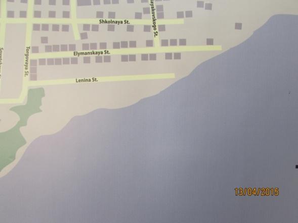
The description of Kapustnoe
Kapustnoe is another part of Pozhva. It is a habitable part of the settlement. It has got only houses here.
It is situated on the left bank of the river Pozhva in the south of the settlement. There is a forest in the south-east of Kapustnoe. It is a quiet place with the houses and some parts of the streets. The countryside around this place is green, with fertile fields and rich vegetation.
There are 3 streets in this part of the settlement. They are Elymanskaya, Lenina and Mayakovskogo. 6
To the south-west of Kapustnoe flows a wide and clear river Kama. The river is lovely for swimming. The fishing is said to be excellent, too.
To the south –west of Kapustnoe there is Gora I with its different sights.
To the north of Kapustnoe there is Gora II.
There are the summer residents in this part of the country too.
I like this part of our settlement very much. This place is for those people who are looking for peace and a lovely rural environment.
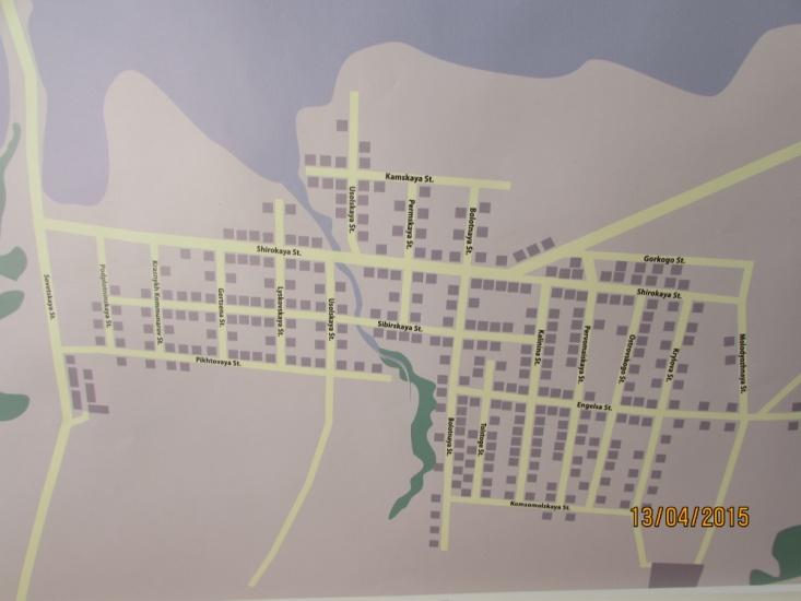
The description of Lyskovo
Lyskovo is another part of Pozhva. It is a commercial center of the settlement. It has got 4 shops, which are situated in different parts of Lyskovo. The first shop is at the beginning of this place, the second – along the main road, the next two shops are in the centre of Lyskovo.
It is situated on the bank of the river Lyskovo in the south of the settlement. The river is lovely for swimming. The fishing is said to be excellent, too. There is a forest behind Lyskovo. It is a quiet place surrounded by fields and woods. The countryside around this place is green, with fertile fields and rich vegetation.
There are 20 streets in this part. They are Podplotninskaya, Krasnykh Kommunarov, Gertsena, Lyskovskaya, Usolskaya, Permskaya, Bolotnaya, Tolstogo, Kalinina, Pervomaiskaya, Ostrovskogo, Krylova, Molodyozhnaya, Pikhtovaya, Komsomolskaya, Usolskaya, Kamskaya, Shirokaya, Sibirskaya and Gorkogo.
To the south-west of Lyskovo there is a nice pond.
To the south –east of Lyskovo there is Lempikha with its different sights.
There are the summer residents in the country.
I like this part of our settlement very much. This place is for those people who are looking for peace and a lovely rural environment.
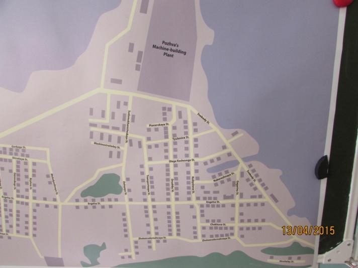
The description of Lempikha
Lempikha is another part of Pozhva. It is an administrative, a cultural, a judicial, a commercial and a working center of Pozhva. It has got well-built houses.
It is situated on the bank of the river Kama in the south of the settlement. There is a forest behind Lempikha.
7
There are 15 streets in this part. They are Sudomekhanicheskaya, Dalnyaya, Transportnaya, Druzhby, Kuibysheva, Gagarina, Engelsa, Zheleznodorozhnaya, Chekhova, Stroiteley, Pionerskaya, Tyulenina, Olega Koshevogo, Svobody and Naberezhnaya.
In the centre of Lempikha there is a plant, a politia, a Settlement Soviet, a library, a Basic school number 2, a kindergarten “ Cheburashka”, the housing and communal services, a post-office. There are 6 shops, a chemist’s shop, the bar, the café, the bakery. There is a sawing, the surgery. There are the places of entertainment and recreation, a park, the children’s playgrounds, a football field and a skating-rink. There are the summer residents in the country.
I like this part of our settlement very much.
8
4. The Conclusion
I have finished the research work the theme of which was “The Maps of Pozhva” in English for the students of the 10th form”, for describing the geographical position of the settlement. I have examined different maps of our native settlement.
There are some photos in the work about different maps and places of Pozhva. I described different places of Pozhva in English. Such as Ratanka, Gora I, Gora I I, Kapustnoe, Lyskovo and Lempikha. I wrote about the streets and houses of Pozhva.
I found the information about different maps of Pozhva such as The Sputnik’s Map of Pozhva, the GPS’s Map, the Vector’s Map, the Cadastral’s Map, the Topography’s Map, the Interactive Map of Pozhva and the Map of Pozhva which is drawn by Irina Andreevna Gudovshchikova. It is in the Pozhva’s Fire brigade. It is large. There are all places of Pozhva there such as: Ratanka, Gora 1, Gora 2, Kapustnoe, Lyskovo and Lempikha. It is the most suitable one to describe the geographical position of Pozhva.
9
5. The List of Literature
Карта Пожвы
101karta.ru›naselennogo-punkta/pozhva-505665
Определите местоположение Пожвы на карте.
2. Пожва со спутника | Пожва
Pozhva.ru›map
Представляю вашему вниманию интерактивную карту п. Пожва. ... Если у вас есть красивые виды Пожвы и ее окрестностей, а также улицы поселка, добавляйте их на...
3. посёлок городского типа, пгт Пожва - карта Пермский край...
Tochka-na-Karte.ru›modules/travel/map.php…
Карта посёлка Пожва с достопримечательностями - вы можете перемещаться покарте ... карту с помощью кнопок '+' и '-'. Карта Пожва, посёлок городского типа, пгтПожва...
4. ПОЖВА - Карта
marshruty.ru›Places/PlaceGoogle.aspx…
Сообщество туристов, путешественников и любителей активного отдыха. Все о туризме: велотуризм, горный туризм, спелеотуризм, пеший туризм, автостоп, водный. На сайте...
Отобразить на карте. Идет загрузка карты ... Очистить карту. на весь экран. ПОЖВА на картах. скачать. искать карты в этом районе.
5. Карта Пожвы со спутника, фото из космоса, где находится Пожва...
extrip.ru›russia/pozhva/map
Карта Пожвы. Где находится Пожва на карте России, как добраться до Пожвы, улицы города Пожва.
6. Пожва — Википедия
ru.wikipedia.org›Пожва
По́жва — посёлок (до 2002 года посёлок городского типа) в Коми-Пермяцком округе Пермского края России, располагается в Юсьвинском районе. Населённый пункт расположен на берегу Камского водохранилища в месте впадения реки Пожвы...
7. Карта Пожва с улицами и номерами домов онлайн
bravica.pro›ru/map/russia/perm/pozhva.htm
Карта Пожва с улицами и номерами домов, подробные географические и спутниковыекарты на русском языке бесплатно онлайн на Bravica (Бравика
8. Пожва - карта №2 / Россия
world-maps.pro›карта_Пожва 10
Пожва. Карта Яндекс. Позволяет: изменять масштаб; измерять расстояния ... Пожва - онлайн карта с видом со спутника: улицы, дома, районы и другие объекты.
9. Карта города Пожва с дорогами Rusija
rasstojanie.com›pozhva
Пожва на карте. Это обширная интерактивная карта Пожва. Она поможет вам сориентироваться в городе, спланировать маршрут прогулки и уточнить.
Карта: ПОЖВА, Пермская область, Россия, Европа
Mira-Karta.ru›Russia/Perm-Krai/Pozhva/
Подробная Гугл Карта ПОЖВА. Политическая Карта ПОЖВА на русском языке. Населенные пункты.
Река Пожва на карте Пермского края | Карта для туриста...
travelel.ru›reka-pozhva-na-karte-permskogo-kraya
Каждый турист знает, что без карты путешествовать сложнее. Карты России, картымира, карты со спутника, карты стран, карты областей России.
12. Карта: Поселок Пожва (Poselok Pozhva)
ripcity.ru›geo-map144903.htmКарта: край Пермский, р-н Юсьвинский, п. Пожва. Географическая карта выбранного места. Выберите на карте элемент "Еще" для получения вида со спутника.
13. Пожва Юсьвинского района Пермского края
BankGorodov.ru›Пожва
поселок Пожва на карте. ... Поселок Пожва является административным центром муниципального образования «сельское поселение Пожвинское
14. Карта поселка Пожва - детальные карты: топографические...
mapsshop.ru›karty_poselka_pozhva/
Совместимость Электронная карта поселка Пожва может быть установлена на мобильные телефоны, планшеты, ноутбуки, навигаторы
15. ...Пожвы с телевышки – Россия, Пермский – Фотографии на карте.
images.esosedi.ru›foto_pozhvyi_s_televyishki…
Фотографии со всего мира с привязкой к карте. Вливайтесь, и делитесь своими произведениями. ... «Фотографию Фото Пожвы с телевышки»
16. Пожва поселок сайт, карта, погода
miselo.ru›site/poselok/pozhva/113745
Поселок Пожва состоит из 72 улиц и больше 64 домов. Поселок занимает 112250 место среди Пермский край по количеству домов. 11
17. Пожва, Карта Пожва, Спутниковая карта, подробная карта, фото...
24map.ru›cat3303/95276-.html
пожва,погода в пожве,Города, основанные в 1754 году, Карта Пожва,,Пожва. ... Пожва— посёлок городского типа в Коми-Пермяцком окружении Пермского края Русской...
18. Пожва, Достопримечательности, История, Интересные факты
travellers.ru›city-pozhva
Пожва Посмотреть на карте. ... Пожва — посёлок городского типа в Коми-Пермяцком округе Пермского края России, располагается в Юсьвинском районе.
19. Гугле карта: ПОЖВА, Пермская область, Россия, Европа
google-karta.ru›Russia/Perm-Krai/Pozhva/
Подробная спутниковая карта ПОЖВА. Гугле Карта ПОЖВА на русском языке. Населенные пункты.
20. Герб Пожвинского сельского поселения | Геральдика.ру
geraldika.ru›Геральдика.ру›31378
Обоснование символики: Правая часть окрашена в зеленый цвет, что символизирует обширные леса Пожвы, расположившиеся по берегам реки Кама
21. Интерактивная карта п. Пожва | Форум
komiperm.ru›forum/index.php…
4 декабря 2008 Представляю вашему вниманию интерактивную карту п. Пожва. … Картадоступна по адресу www.pozhva.ru/map.
Всего 5 сообщений
22. Пожва
wikimapia.org›3129156/ru/Пожва
Карта, создаваемая вами! ... Историки любовно именуют Пожву «родиной первых русских пароходов», «колыбелью отечественного парового судостроения».
23. http://extrip.ru/russia/pozhva/map
3. И. Ю. Баканова, Н. В. Береговая, Н. Г. Брюсова и др. Английский язык: Большой справочник для школьников и поступающих в вузы. – 2-е изд. – М.: Дрофа, 1999.
И. Ю. Баканова, Н. В. Береговая, Н. Г. Брюсова и др. Английский язык: 600 устных тем для школьников и поступающих в вузы. – М.: Дрофа, 1999.
Г. Е. Выборова, К. С. Махмурян. Тесты по английскому языку для школьных олимпиад. Учебное пособие. – М.: «Флинта», «Наука», 1999. 12
Т. Ю. Журина. 55 устных тем по английскому языку для школьников. – 2-е изд. – М.: Дрофа, 1997.
Е. Л. Занина. 95 устных тем по английскому языку. – 2-е изд. – М.: Рольф, Айрис-пресс, 1999.
В. Каверина, В. Бойко, Н. Жидких. 100 тем английского устного. – М.: ЗАО «БАО-Пресс», 1999.
Г.Л. Кубарьков., В. А.Тимощук. Сборник новых 1000 тем современного английского языка. Издательский дом Удача. Ростов-на-Дону. БАО-Пресс. Москва 2007г.
В. П. Кузовлев. English Student’s Book. Учебник для 4-го класса общеобразовательных учреждений. 7-е издание. Москва «Просвещение» 2009 г.
А. П. Миньяр-Белоручева. Английский язык для школьников и абитуриентов. Тексты для чтения по истории, социально-политической и культурной жизни Великобритании и США. Упражнения для формирования навыков письма и устной речи. – 8-е изд. – М.: «Экзамен», 2007.
Г. М. Фролова. Курс английского разговорного языка. Книги 5,7, 8,9,10, 22, 39, 40. – М.: Мир Книги, 2002.
Пожвинский завод. Историческая хроника 1754 — 2004. П. М. Казанцев, Кудымкар. Коми-пермяцкое книжное издательство, 2004 год.
«Журавли». Игорь Юрькевич, п. Ильинский, 2009 год.
13
6. The Supplement
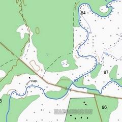
The Physical Map of the location of Pozhva
14
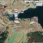
The Sputnik’s Map of Pozhva
The GPS’s Map of Pozhva
15
The Vector’s Map of Pozhva
The Cadastral’s Map of Pozhva
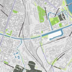
16
The Topography’s Map of Pozhva
17
The Interactive Map of Pozhva
18
The Map of Pozhva is drawn by Irina Andreevna Gudovshchikova
20
The Map is drawn by Yuliya Kopylova, Kseniya Zhigulyova and Tatyana Simakova, the students of the 10th form.
21
And One of the most suitable Maps to describe the geographical position of Pozhva was done in Kudymkar in 2015.
22
The Map of Zaratanka.
The Map of Gora I.
The Map of Kapuctnoe.
23
The Map of Gora II.
The Map of Lyskovo.
The Map of Lempikha.
 24
24
Полезное для учителя


Распродажа видеоуроков!
2000 руб.
3080 руб.

1640 руб.
2530 руб.
1630 руб.
2510 руб.

2000 руб.
3080 руб.
ПОЛУЧИТЕ СВИДЕТЕЛЬСТВО МГНОВЕННО
* Свидетельство о публикации выдается БЕСПЛАТНО, СРАЗУ же после добавления Вами Вашей работы на сайт
Удобный поиск материалов для учителей
Проверка свидетельства